Noon
A few hours later and there are still a lot of discrepancies that are making this storm one of the most difficult to deal with that I have encountered this season. That common thing is that for most elevations below 8,200 feet, the majority of the precipitation, be it rain or snow will occur in a 6 hour period. At the moment that period looks to occur between 11 am and 5 pm on Saturday. This does not mean it is over after that, moderate to heavy precipitation will continue across the passes and Purgatory and Telluride thru Monday. At lower elevations, it will be spottier.
So my latest conundrum is will the 6 hour period be delayed? I can’t answer that yet and I have not yet seen signs of that happening but I hope to be dialed in better after the morning model runs a well as adhering to the number one principle of storm analysis: Step One (look outside).
It is really pretty fascinating to see how these 6 hour periods stack up.
First the GFS this the total liquid precipitation equivalent between 5 am and 11 am. There are two blue lines the darker blue is 32 degrees, the light blue line is 35 degrees.

Here is the same time period for the Euro
Pretty similar
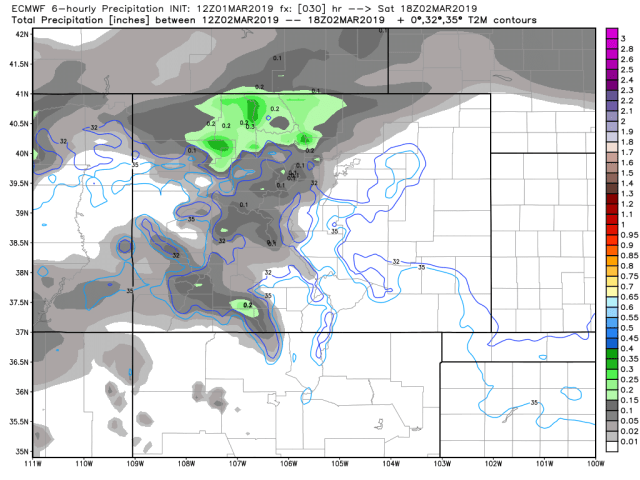
Next, the GFS between 11 am and 5 pm

Now the Euro same time period
Here is something interesting on the Euro that the GFS does not have for lower elevations. Below is the 6-hour snowfall between 11 am and 5 pm on Saturday.

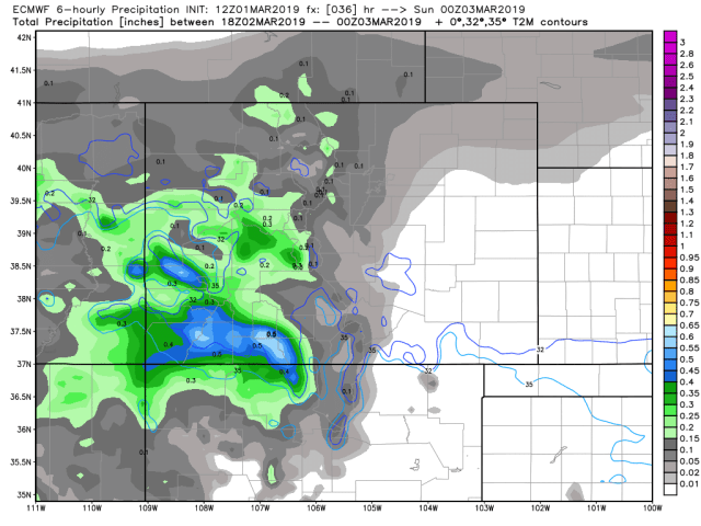
Back to liquid precip here is the GFS from 5 pm to 11 pm on Saturday night

And the Euro for the same time period

This clearly shows the model expects most of the precip in lower elevations will fall in one 6 hour time period.
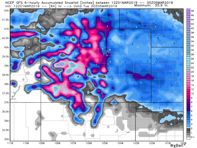
By the time this thing wraps up completely late Monday here is the GFS projected liquid totals. Because of the low resolution, the GFS is always too low for Wolf Creek, and likely too high for Telluride.

Here is the GFS for total snow
Here is the Euro total liquid

Here is snow from the Euro

This does not take into account any melting.
The high at the airport is forecasted to be around 38 on Saturday. It is not unusual for snow to fall with very heavy convective showers even up to 40 degrees. The key is the colder air and how close it gets to us that I talked extensively about this morning.
I am still not quite comfortable on low and mid elevations totals yet, but I think that 10-15 looks good for Purg and Telluride with 18-24 for Wolf Creek.
Many of you have asked about travel conditions Saturday and Sunday evenings.
Montrose Saturday evening
Here is a look at conditions between 11 am and 5 pm between Durango and Montrose which I identified with a black dot. Light blue is light snow the darker the blue the heavier the snow. Pink is freezing rain, orange is ice.

For travelers wanting to drive back from Gunnison on Sunday.
Here is a look at conditions first between 11 am and 5 pm on Sunday. I put a little black dot on Gunnison for your reference. Light blue is light snow the darker the blue the heavier the snow.

And between 5 pm and 11 pm

That orange is ice in southern La Plata County.
That is the best I can do today but of course, I will get something out early tomorrow.
If you missed my morning update check that out here Time To Change Things Up & My Take On The New Warnings Posted
Stay tuned, we could at least double these amounts over the next 7 to 10 days.
Click here to donate
Click here to contact me