Yesterday the clouds suppressed the convection from developing the storms we had hoped to see. There were several areas that did get some rain, but it was similar to what we have been seeing for the last week. The Monsoonal moisture tap seemed to shut down after it moved that initial surge into the area Tuesday evening.
Here was what the Euro showed yesterday morning, and it is why I said I was concerned with what I was seeing in Arizona.
Yesterday afternoon. Notice the lack of activity(depicted in green) throughout Arizona.

Here is the same model today showing what to expect this afternoon. The moisture is further west than yesterday.

Here is what it expects tomorrow. You can see the heavier pockets make it up to our area and the coverage is more widespread.

So for today expect another round of scattered showers. Some areas will be luckier than others. Tomorrow is a different story, at least that is what I am hoping for.
All of the models are predicting some very decent totals through Sunday afternoon.
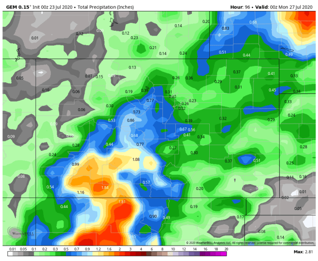
Here is the German model which usually has a very dry bias in our area.

The Canadian
The Euro model

And the GFS model which is very similar

Impressive totals for 4 days!
Based on the 10-day totals it looks like the moisture tap will get shut down for a few days and then reappear later in the week.
10 day Canadian

10 day Euro

10-day GFS

Next update on Friday. Thanks for your support and thanks for following!
Click here to donate
Click here to contact
Hi………0.47-inch of rain…north end of CR 228 at CR 502…as of 10 P.M. last night !!