12/26/22 Monday 7:40 am
Late Tuesday into Wednesday morning copious amounts of moisture will reach the forecast area. Heavy mountain snows of 1 to 2 feet will be possible at or above 8,000 feet by Thursday night with the first storm. A series of storms will then move through the area between late Friday through Tuesday, January 3rd.
The biggest challenge will be snow levels with the first storm. Right now it looks like all snow at or just above 8,000 feet. Snow levels will drop to 6,500 feet and lower by Wednesday night and Thursday morning.
I do expect pass closures during the storm and Friday between the storms. Automobile travel will be impacted again in the midwest, and flights will likely be affected in Durango on Wednesday night, Thursday morning, and Thursday during the day in Denver.
I have a lot of fun maps to share so let’s jump right in.
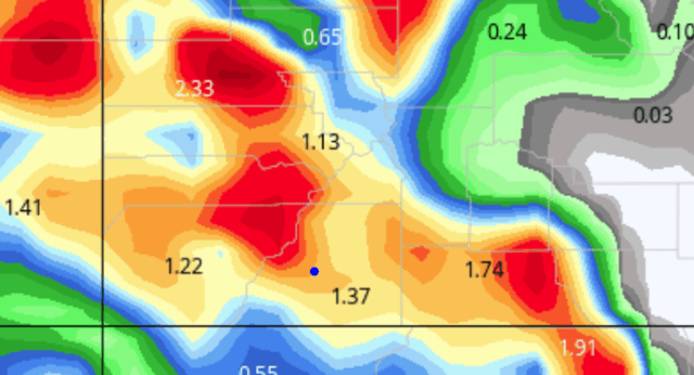
First, we will look at total liquid precipitation from late Tuesday through Thursday evening. Then I will post the snow maps. All maps are shown in inches. Keep in mind, the snow maps do not account for melting and compaction and they tend to under forecast the higher elevations and overdo the lower elevations. The snow maps are based on a 10-1 snow-to-liquid ratio.
European liquid equivalent


GFS liquid equivalent

![]()
Canadian liquid equivalent
![]()
NOAA’s high-resolution blended model NBM

![]()
European snow (10 to 1) before melting and compaction

![]()
GFS snow

![]()
Canadian snow

![]()
Yesterday I posted precipitation maps through the middle of next week. These maps only depict snow and liquid equivalent through Thursday.
A Winter Storm Watch has been issued for areas above 8,000 feet late Tuesday through late Wednesday. I would expect that this watch will be extended through Thursday morning. I also expect a Winter Weather Advisory or Winter Storm Warning for the lower elevations beginning Wednesday night.
URGENT – WINTER WEATHER MESSAGE
NATIONAL WEATHER SERVICE GRAND JUNCTION CO
306 AM MST MON DEC 26 2022
COZ009-017>019-UTZ028-262100-
/O.NEW.KGJT.WS.A.0013.221228T0000Z-221229T1200Z/
GRAND AND BATTLEMENT MESAS-UNCOMPAHGRE PLATEAU AND DALLAS DIVIDE-NORTHWEST SAN JUAN MOUNTAINS-SOUTHWEST SAN JUAN MOUNTAINS-LA SAL AND ABAJO MOUNTAINS-
INCLUDING THE CITIES OF RIDGWAY, GLADE PARK, TELLURIDE, OURAY,
LAKE CITY, SILVERTON, RICO, MAYDAY, AND MONTICELLO
306 AM MST MON DEC 26 2022
…WINTER STORM WATCH IN EFFECT FROM TUESDAY AFTERNOON THROUGH LATE WEDNESDAY NIGHT…
* WHAT…HEAVY SNOW IS POSSIBLE MAINLY ABOVE 8000 FEET. TOTAL SNOW ACCUMULATIONS OF 10 TO 18 INCHES WITH UPWARDS OF 2 FEET
POSSIBLE.
* WHERE…IN COLORADO, GRAND AND BATTLEMENT MESAS, UNCOMPAHGRE PLATEAU AND DALLAS DIVIDE, NORTHWEST SAN JUAN MOUNTAINS AND SOUTHWEST SAN JUAN MOUNTAINS. IN UTAH, LA SAL AND ABAJO MOUNTAINS.
* WHEN…FROM TUESDAY AFTERNOON THROUGH LATE WEDNESDAY NIGHT.
* IMPACTS…TRAVEL COULD BE VERY DIFFICULT. PATCHY BLOWING SNOW
COULD SIGNIFICANTLY REDUCE VISIBILITY, ESPECIALLY ON RIDGE TOPS
AND MOUNTAIN PASSES.
_________________________________________________________
As far as Wolf Creek pass goes, there is a Winter Storm Watch, and I expect 18 to 24 inches with winds up to 50 mph.
I will do another model update this afternoon. My storm forecast will be out Tuesday afternoon. Thanks for following and supporting the site!
Click here to donate
If you prefer to donate with Venmo: @Jeff-Givens-11
Click here to submit a weather report or question
Send your weather videos to: durangoweatherguy@gmail.com