

Before I jump into the next storm I wanted to share the new snowpack numbers for the high country.


The column next to the end on the right is the one to look at “Percent of Today’s Median”. Cascade, Vallecito, Lemon, and the La Platas look great for now. The new drought monitor will be out tomorrow and I am hoping we will go to a D1 from the current D2 in our area.
Thursday Storm
After prolonged storms with a lot of interesting and complex twists and turns, it is difficult to get too excited about the incoming smaller storm. The struggles will be similar to what we just saw late last week. Most importantly we will start with higher snow levels (around 8,500′). As the front approaches, snow levels should drop to 6,500′ and the front should pass with a lot of fanfare (again) and even if it is short-lived (again) many people found out what nearly impossible travel conditions look like last week. Timing is the other important variable, I am already starting to see some slowing in the models. Looking at the meat of the storm it looks slightly deeper and stronger than 24 hours ago, so these are all positive signs.
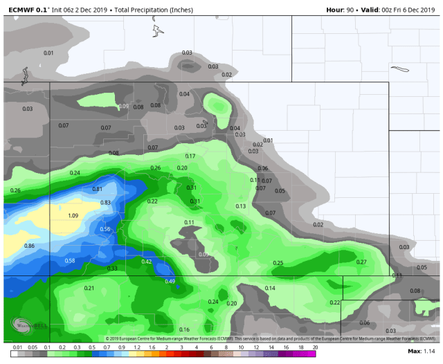
Due to the uncertainty of the snow levels at this time, I am just going to show the snow water equivalent numbers (SWE) or liquid precipitation. I am expecting all snow above 8,500′ so multiply by 10 or 12 if you are above 8,500′.
I am also going to show the last two runs from the operational models.
Euro last night


Euro overnight
Euro this morning

GFS last night

GFS overnight

GFS this morning

These are just a few of the many parameters I look at, but it is good way to see some of the solutions the models are coming up with.
After this storm, a system will try to brush by to our north on Sunday then it looks like we will be dry until at least the 15th when it looks like a stormier pattern will return.
Next Update Tuesday around noon.
Click here to donate
Click here to contact me