Two of the reasons I started the afternoon Weather 101 series are based on feedback that I received from followers. Several followers kindly wrote in saying that reading my blogs helped take their mind off of what was going on and that my posts were a nice alternative to getting caught up in the 24/7 doomsday news cycle. That hit home a bit because I too have distanced myself from a lot of what has been going on. I stay up to date on the facts like the latest count in Colorado, and relevant news from SW Colorado. But that’s it, I avoid all opinion and speculation from the media. That leaves me with work, music, writing and selected recorded television. The actual idea behind the Weather 101 series was because people also contacted me saying, “I seem to suddenly have some free time on my hands this week, can you talk more about ______”.
Snowpack Update Where We Are At
This is something that I have not addressed in a long time. After last year we were very spoiled by seeing huge snowpack numbers from mid-winter to June. This year is different, that is true. But would it surprise you to know that the actual numbers are not too bad? I honestly hadn’t looked because I assumed it was horrible. In fact, I had on Weather Nation yesterday morning and the forecaster misspoke, I am not sure if he even realized he said it. I am sure it is difficult to get up in front of a large viewing audience, cameras going, and improvise. But he pointed towards SW Colorado and said: “the moisture is definitely needed here because the snowpack sits at 38% of average”. I knew this was wrong, regardless of how you would intentionally try to manipulate the numbers-which I don’t believe he did. So I looked, for the first time this season, I finally looked. Here is what I found, this applies only to our area, and it is not lumped in with some of our State’s broader averages.
This was the Sunday night report that was available yesterday.
Data courtesy of USDA National Resources Conservation Service
![]()


The easiest thing to track is the last two columns on the right. Percent of Todays Median and Median Peak. So you go through and pick the area you are interested in. In another few weeks, I will detail where some of these sites are but one everyone can relate to is Vallecito (at 10,880 feet). Vallecito usually peaks on April 7th (it was much later last year). This shows that Vallecito is already at 103% for the season, and 119% of what is historically typical for this year. This is good news, especially looking ahead at the potential for continued precipitation for the next couple of weeks!
The Storm Countdown Begins
Model Analysis
The biggest change in the last 24 hours is with the GFS and Euro moving away from the idea of a second storm over the weekend. Rather, they each show a bit of a lull on Friday followed by a reinforcing lighter shot of precipitation Friday night into Saturday morning. Both models show additional precipitation coming in Monday/Tuesday next week, but disagree regarding the intensity of that system. The Canadian still shows a second storm over the weekend, then shows an unsettled week without any really distinguishable features. The Euro shows a big storm next week, the GFS shows a smaller storm, both models are exhibiting their own biases so I don’t think it is appropriate to go into details for a couple of days.
This takes us up to the model runs, just like the last couple of days I am posting the last two most recent runs from the four models we have been tracking. Stop times vary by model-basically I stopped it when the precipitation stopped. Although these maps list liquid-equivalent precipitation, I should point out that although this storm will start out warm it looks like it will finish colder than the last storm, I do expect accumulating snow down to the lower elevations by Thursday morning.
Euro oldest through Saturday morning

Euro latest through Saturday morning

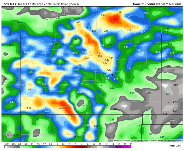
GFS oldest through Friday night

GFS latest through 3am Saturday morning
Canadian through noon Friday (there was a definite stop at that time)
Canadian latest through noon Friday
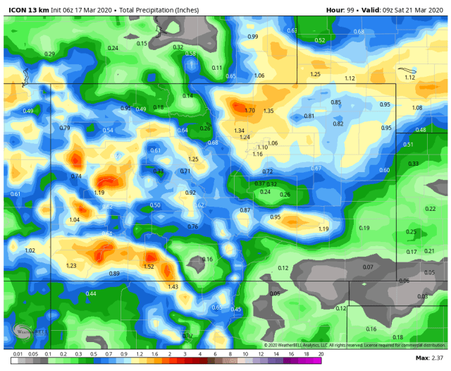
ICON oldest through Midnight Saturday morning

ICON latest through 3 am Saturday morning
I will do another Weather 101 post later today. Also, I expect to see the NWS issue some type of watch or warning late this afternoon, I will highlight that when/if it comes out.
Thanks for following and continuing to support the site!
If you have not read about the contest yet, make sure you check it out by clicking here: End Of The Season Announcement-The Contest If you wish to donate by check, click the blue contact link and I will email you instructions.