The GFS is back to showing a glancing blow (near-miss) for most of the forecast area. The Canadian has backed off very slightly. However, the Euro is still forecasting a long-drawn-out storm with a closed low churning the storm out of the southwest and across our entire forecast area bringing a lot of liquid and frozen precipitation.
If you are planning on traveling in the state between Saturday and the middle of next week, you should check in daily to see how the models evolve this week.
While I am delighted to see what the Euro and Canadian are forecasting, I will be happier if I see all of the models converge on a solution by Friday.
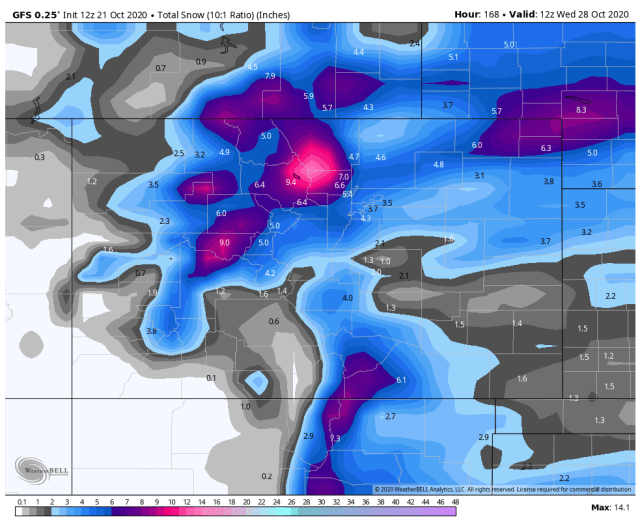
Here is the rather anemic GFS
GFS liquid

GFS snow
The Canadian has calmed down in the last 24 hours but still looks good! In an unusual take, the Canadian is warmer than the Euro. This is unusual because the Canadian is a cold-biased forecast model. It is also a low-resolution model so it spreads the precipitation over a widespread area.
Canadian liquid

Canadian snow
Last is the Euro which has been the most consistent to itself over the last 24 hours. The Euro starts as rain in the lower elevations then switches over to snow dropping huge accumulations over the area especially for October.
Euro liquid

Euro snow

As I said the Euro has had the best run-to-run consistency, but that does not mean it won’t change. I hope for the best but will feel a lot better about the situation if it keeps this storm track for the next 48+ hours.
As far as travel guidance goes, it will likely be Friday before I can go into the timing and specific details. All I can say is stay tuned.
Thanks for following and all of the support! Next Update Thursday afternoon.