1/4/19
A large Pacific storm will merge with a subtropical tap of moisture coming from just west of Baja California to bring us more snow. It will start close to or after midnight and continue through the day on Sunday. At the moment the models are indicating 3-6″ of snow for the lower elevations including Bayfield, Durango, Cortez and Mancos, with 5-10″ for Purgatory and from Dolores to the north. More than a foot should fall at Wolf Creek. I will tighten these up tomorrow. The snow is going to be more dense than what fell with the last two storms. The data I am looking at right now shows a snow/rain level rising to 6,300 feet on Sunday around 2 pm. I will be updating this on Saturday and Sunday. This keeps the snow to liquid ratio around 10-1 for almost all areas until the end of the storm when they raise to about 15-1. If we get “leftovers” this could be a good thing. By “leftovers” I am referring to any little piece of energy or disturbance that produces more snow while/after the storm is departing area. Another thing is we could have some surprises around Cortez, for some reason some of the models are highlighting these areas.
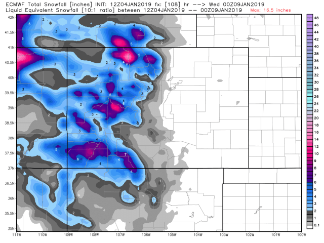
The graphics below depict total accumulations for the storm.
Current Euro
Morning NAM

GFS it’s still the outlier

As I was writing this the afternoon NAM model came out and it continues to trend up! It may be an anomalous run or a trend. I guess we will find out tomorrow.
Afternoon NAM

I expect Winter Weather Advisories to be issued either this afternoon or tomorrow morning. Usually, a WWA at lower elevations is issued when 3-6″ of snow is expected. For elevations above 8,000′, a WWA is issued (usually) when 6-12″ of snow is expected.
Another important thing to mention, the warm moist air will come in first and may leave a slick coating of ice on snowcovered side streets or rural roads so be careful Sunday morning!
Click here to donate
Click here to contact me
GFS
