10/30/22 Sunday 7 am
There are now 30 chances to win cash or prizes in the 2022 Contest this year. If you have not checked it out yet click here: 2022 Contest Updated 10/30/22
The models are getting slightly more consistent on a run-to-run basis. Warm and windy conditions on Tuesday will transition to cold, wet, and sloppy for a couple of days beginning very late Wednesday /early Thursday. Travel will be impacted in the mountains and some of the mid-elevation areas. The passes will be especially messy. If you have major travel planned on Thursday to Friday which will take you over the passes expect it to take delays.
The models agree on the timing at the moment, but they don’t agree on the exact track of the storm. There is a chance that a piece could go south and impact Northern New Mexico. If you are planning on driving to ABQ you could be affected as well.
The other piece of the puzzle is the snow level. Before it’s done I expect snow well below 7,000 feet this time. The GFS shows a warmer storm and the Euro shows a colder storm. A lot of that will have to do with the storm track and it is too early to figure that out. If I were pressed I would say all snow at 8000 feet or above.
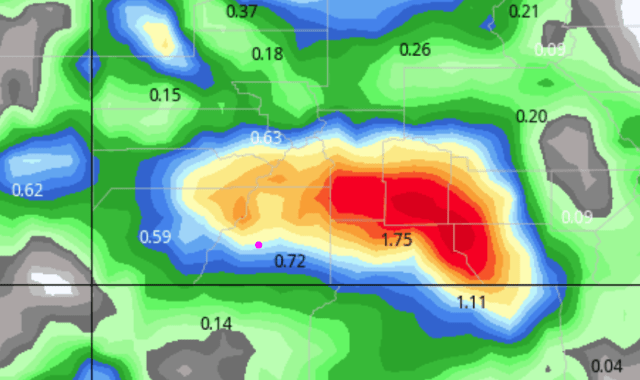
Here are the liquid precipitation forecast maps from the latest runs of our favorite models. Multiply by 10 at or above 8000 feet for snow forecasts.

Canadian

GFS

German
NOAA WPC

NOAA Nation Model Blend

My next update will be on Monday. Thanks for following and supporting the site and the contest!
Click here to donate for a chance to win
If you prefer to donate with Venmo: @Jeff-Givens-11
Click here to submit a weather report or question
Send your weather videos to: durangoweatherguy@gmail.com