3/17/23 Friday 9 am
Yesterday afternoon rain and snow showers redeveloped across the forecast area. As expected, Wolf Creek was the largest beneficiary adding 12 inches to their storm total. Snow showers will redevelop again, perhaps Saturday as well, and Wolf Creek will be the most favored location.
It is almost as if Wolf Creek knows that Purgatory will break the 2018-2019 total so it also wants to break its 2018-2019 total. For that to happen, they need 102 more inches. Considering that 60+ inches could come between now and next Friday, I am not ruling that out!
Before I get to the models, here is the latest information on our overly abundant snowpack.

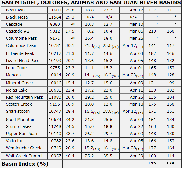
From left to right is location; elevation; current Snow-Water Equivalent in liquid inches; the normal average for this date in liquid inches; the normal average for the entire season for this particular location in liquid inches; the date that this location achieves its seasonal average. The last two columns on the right are the percentage of the average for the current date and the percentage of the seasonal peak average for the entire season.
So, for example, from this table you can derive the following:
Wolf Creek Summit@10,957′ elevation is showing 40.4 liquid inches of precipitation. Normally on this date, the site has 25.2 liquid inches. The seasonal average for this sight is 35.5 inches and it reaches that peak on April 29th. For this date, Wolf Creek Summit is at 160% of the average and is at 114% of the seasonal peak average
On the bottom, it shows the average percentage of all locations in these basins for this day is 155% and 129% for the seasonal peak. It will be fun to see where this is at next Friday or Saturday!
Next week a couple of storms are going to move through, but at this point, the models don’t show any appreciable break between the two systems so for the purposes of this discussion, we will act as if it is one storm.
All of the models show snow breaking out on Monday. It is too early to pin down a start time, so I will just stick with “sometime” on Monday. As I said earlier there will be a couple of pushes of energy through the area next week but I expect precipitation all week long, perhaps even into next weekend when a third system may move in. At the moment, I am going to concentrate on next week and I will revisit next weekend in a few days.
It is also too early to predict the accumulating snow levels. All I can say is that all of the models are predicting some accumulating snow in the lowest elevations of the forecast area. They are also suggesting this could be a big snow week in the middle elevations. It is going to be a horrible week for automotive travel over the passes.
Here are the latest model runs for total liquid precipitation from Monday’s first flake through Friday morning.
European

![]()
GFS

![]()
Canadian

![]()
Here is NOAA’s WPC high-resolution blended model. The only parameter that I can run with this is the 7-day total. This run includes anything that falls this weekend plus next week.

My next update will be on Saturday. Thanks for following and supporting the site!