11/19/23 Sunday 7:40 am
The next area of low pressure is working its way into western Utah this morning. Depending on which map I believe, the front is becoming slightly stationary.

Or. The cold front is transient, and there is an additional shortwave stretching from central Utah to just north of Grand Junction.

Either solution probably won’t change the big picture today and tonight.
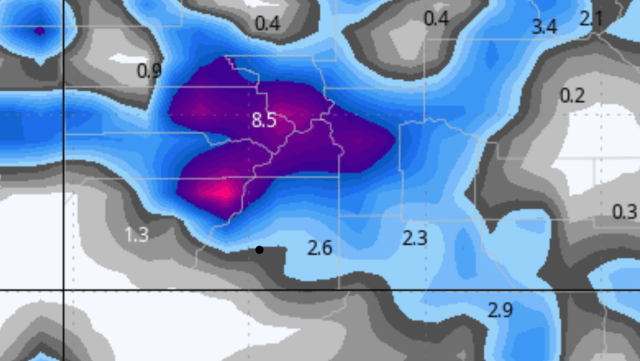
Here are the snowfall forecasts from four weather models this morning. This is total snowfall, before any melting may occur. These totals are from now through Monday morning. As always I “black dotted” Durango. New this year, my service has included amounts north of Bayfield on the way to Vallecito. It does not show up geographically correct on these maps, but that is where they are referring to. I have no control over this.
GFS–In this case, that spot is the 2.9. BTW 6.5 is Telluride 0.3 is Montrose and 2.4 is Pagosa.

![]()
Canadian
![]()
European–Notice the Euro emphasizing the western portions of the forecast area. I started noticing this yesterday.

![]()
This emphasis is even more noticeable in the high-resolution NAM3km model. This is the most recent run, literally just out. For some reason, it is jumping all over some mid-elevation upside surprises west of Durango along the 160 corridor. I am not confident it is correct, but we will see!

![]()
Right on cue, a quick look out my office window shows it is snowing at my house in DWest 2.
So far, there are no changes to the Winter Weather Advisories issued yesterday.
I will check back in later this afternoon.
Thanks for following and supporting the site!