2/22/23 Wednesday 12 pm
I hope this does not surprise anyone…
US 160 Wolf Creek Pass is CLOSED
– 11:40 a.m. (2/22/23)Thanks for following and supporting the site!
2/22/23 Wednesday 12 pm
I hope this does not surprise anyone…
US 160 Wolf Creek Pass is CLOSED
– 11:40 a.m. (2/22/23)Thanks for following and supporting the site!
2/22/23 Wednesday 10 am
Are we having fun yet?
Thanks for following and supporting the site!
2/22/23 Wednesday 8:50 am
These adverse conditions are moving east. Avoid travel today.
US 550 is closed due to adverse conditions from just north of Purgatory to Ouray. (MP 48-92).
Once again here was the 1st closure.
US 491 from just north of Cortez to Dove Creek (MP 30-65) is closed due to adverse conditions. CDOT Patrols are reporting zero visibility. Plow operators cannot see their blades. Colorado State Patrol reports winds are pushing parked CMVs. CDOT urges big rig drivers and passenger vehicle motorists traveling east from Monticello, UT to stop. Do not drive into Colorado. Driving conditions are treacherous.
Lisa Ann Schwantes
Thanks for following and supporting the site!
2/22/23 Wednesday 8:40 am
US 491 from just north of Cortez to Dove Creek (MP 30-65) is closed due to adverse conditions. CDOT Patrols are reporting zero visibility. Plow operators cannot see their blades. Colorado State Patrol reports winds are pushing parked CMVs. CDOT urges big rig drivers and passenger vehicle motorists traveling east from Monticello, UT to stop. Do not drive into Colorado. Driving conditions are treacherous.
Lisa Ann Schwantes
Thanks for following and supporting the site!
Don’t be fooled, the main low-pressure system is still west of us. What we have seen so far was a shortwave trough caught up in the flow ahead of the main storm. This is the frustrating portion of the storm, where forecasters start second-guessing everything.
Here is NOAA’s best guess at the current surface map.

Notice the tightly packed lines from Utah to Arizona. Those concentric circles show the strength of the low pressure. Flagstaff airport reported gusts earlier this morning of 72 mph! Temperatures have fallen dramatically with the frontal passage. Also on the map above you can see a dashed blue line with triangles on it from western Utah into Nevada. This indicates another secondary trough is developing behind the main area of low pressure.
Here is Wunderground’s interpretation of the current surface map.

Either could be correct, both tell me despite the current lull, the storm should ramp back up, the temperatures are going to drop and the winds are going to pick up considerably.
Nothing has changed for the forecast. So far the snowfall has outperformed the models. The roads were warm overnight so the snow did not accumulate very much on the surfaces. These wet roads may flash freeze as the colder air moves in.
What snow was left on my roof in my backyard is now blocking me from my measuring site, but it appears 8 inches of wet snow have accumulated as of 6:30 am.
Thanks for following and supporting the site!
The Winter Storm Warnings go into effect at 5 pm tonight. A Blizzard Warning goes into effect on Wolf Creek Pass at or above 10,000 feet at 5 pm as well. Wind gusts exceeding 80 mph are possible on Wolf Creek Pass on Wednesday.
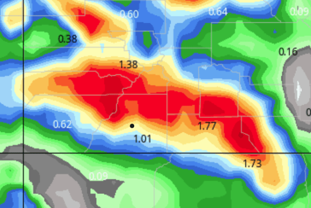
Here are the latest wind gust parameters from the NOAA NBM model for Wednesday. These are the peak wind gusts for the forecast area between tonight and Wednesday night.

![]()
Here are my snow forecasts through Thursday morning. I do expect additional snow on Thursday and Friday, as well as another small storm coming in on Sunday.
I would not be surprised to see some higher totals than what I am forecasting.
Wolf Creek: 32-38 inches
Purgatory, Hermosa Cliffs Ranch: 18-24 inches
Silverton, Rico, Silver Creek Ranch, Mayday, Lake Purgatory: 16-22 inches
North Vallecito, North Lemon: 15-20 inches
Durango Ridge Ranch, Hesperus Hill, Upper Forest Lakes, Upper Durango Hills, Los Ranchitos, Tween Lakes, Glacier: 14-18 inches
Durango West 1&2, Edgemont, Rockwood, Long Hollow, Shenandoah Highlands, Rafter J, Lower CR 207, Lower Forest Lakes, Lower Durango Hills, Pagosa: 12-16 inches
Pine River Ranches, Timberdale, Beaver Creek, Deer Valley Estates, Dolores, Trappers Crossing, Shenandoah: 10-14 inches
Durango in town, Bayfield, Gem Village, Mancos: 5-10 inches
DRO, Ignacio, Cortez: 2-5 inches
Aztec, Bondad: 1-3 inches
I will check in tomorrow and I will post any closure information I get throughout the day. Thanks for following and supporting the site!
2/21/23 Tuesday 8 am
Today will be the warm before the storm across much of the forecast area. This year the Winter Storm Severity Index, or WSSI, was introduced. I usually don’t use the product but since the forecast shows the WSSI maxing out with this storm, what a perfect time to introduce it to followers.
Similar to hurricane forecasts, these indexes are developed to be pretty simple to interpret so I won’t spend a lot of time explaining them.
The following parameters are used to determine the potential severity of the winter storm: Snow Amount; Snow Load; Ice Accumulation; Flash Freeze; Blowing Snow; Ground Blizzard Conditions. They then calculate an Overall Impact Score. Here are the scores with descriptions.

Here is the map for our area, as you can see 90% of the forecast area is in Major or Extreme Impacts.

I took the liberty of putting white dots on the passes. Wolf Creek is on the far right. Lizard Head is on the top left-center. Coal Bank, Molas, and Red Mountain are in the top middle.
Winter Storm Warnings go into effect at 5 pm this evening.
Here are the latest model runs. While I am expecting additional snow on Thursday and Friday, the heaviest snow will fall throughout the day and night Wednesday. Therefore, unlike the last several days. Here are the snow totals through Thursday morning at 11 am.
European–It is still on the lower side of the models

![]()
GFS

![]()
German

![]()
Canadian–Still on the higher side of the models.

![]()
Here is the NOAA blended high-resolution NBM

![]()
My forecast will be out this afternoon by 4 pm.
Thanks for following and supporting the site!
2/20/23 Monday 4:30 pm
Very little has changed, I have gotten several emails from people intending to travel on Wednesday. All I can say is the winds may make this the most dangerous winter storm to drive in so far of the season.
I hope those planning to travel through the mountains on Wednesday are very seasoned Winter Storm drivers with 100% confidence in their well-equipped vehicles for winter driving. The snow squall parameters are literally off the chart, blizzard like conditions will make travel very dangerous.
Here are the latest precipitation runs. The models have all trended up a bit. The totals are through Saturday, tomorrow afternoon, I will try to time the accumulations a little better.
The Euro is up over the last run, but still lagging behind its earlier totals and the other models’ totals.
Euro

![]()
GFS

![]()
German

![]()
Canadian

![]()
My next update will be Tuesday morning. Thanks for following and supporting the site!
2/20/23 Monday 7:45 am
While the GFS and Canadian models have been pretty consistent with their total precipitation for this upcoming storm (and leftovers), the European model is starting to drift. It is important to note that the European has under forecasted the snow totals for 70% of the forecast area for every major winter storm we have had this year.
Winter Storm Watches were issued Sunday for most of the forecast area. Overnight they increased the snow totals in the lower elevations and the possible wind speeds in both the lower and higher elevations.
I have mentioned the wind for the last few days. It will make travel treacherous and avalanche conditions will be very dangerous. Wind gusts up to 70 mph in the lower and mid-elevations and 80 mph gusts in the higher elevations!
Here are the current Winter Storm Watches. Note that these totals and conditions are only through Wednesday night. This does not necessarily mean it will stop snowing Wednesday night. Additional advisories may very well be needed in some areas through Friday night. I guarantee you there will be pass closures and we may see some resorts close if the winds live up to expectations.
COZ003-010-017>019-UTZ025-028-202200-
/O.EXT.KGJT.WS.A.0003.230222T0000Z-230223T1200Z/
ROAN AND TAVAPUTS PLATEAUS-
GORE AND ELK MOUNTAINS/CENTRAL MOUNTAIN VALLEYS-
UNCOMPAHGRE PLATEAU AND DALLAS DIVIDE-
NORTHWEST SAN JUAN MOUNTAINS-SOUTHWEST SAN JUAN MOUNTAINS-
TAVAPUTS PLATEAU-LA SAL AND ABAJO MOUNTAINS-
INCLUDING THE CITIES OF RIO BLANCO, ASPEN, VAIL, SNOWMASS,
RIDGWAY, GLADE PARK, TELLURIDE, OURAY, LAKE CITY, SILVERTON,
RICO, HESPERUS, AND MONTICELLO
236 AM MST MON FEB 20 2023
...WINTER STORM WATCH NOW IN EFFECT FROM TUESDAY AFTERNOON
THROUGH LATE WEDNESDAY NIGHT...
* WHAT...HEAVY SNOW POSSIBLE. TOTAL SNOW ACCUMULATIONS OF 10 TO 20
INCHES POSSIBLE. WINDS COULD GUST AS HIGH AS 80 MPH.
* WHERE...PORTIONS OF NORTHWEST, SOUTHWEST AND WEST CENTRAL
COLORADO AND EAST CENTRAL AND SOUTHEAST UTAH.
* WHEN...FROM TUESDAY AFTERNOON THROUGH LATE WEDNESDAY NIGHT.
* IMPACTS...TRAVEL COULD BE VERY DIFFICULT. WIDESPREAD BLOWING
SNOW COULD SIGNIFICANTLY REDUCE VISIBILITY, ESPECIALLY ON
RIDGE TOPS AND MOUNTAIN PASSES. VERY STRONG WINDS COULD CAUSE
EXTENSIVE TREE DAMAGE. THE COLD WIND CHILLS AS LOW AS 30 BELOW
ZERO COULD CAUSE FROSTBITE ON EXPOSED SKIN IN AS LITTLE AS 30
MINUTES.
COZ020>023-202200-
/O.EXT.KGJT.WS.A.0003.230222T0000Z-230223T1200Z/
PARADOX VALLEY/LOWER DOLORES RIVER-
FOUR CORNERS/UPPER DOLORES RIVER-ANIMAS RIVER BASIN-
SAN JUAN RIVER BASIN-
INCLUDING THE CITIES OF GATEWAY, NUCLA, CORTEZ, DOVE CREEK,
MANCOS, DURANGO, BAYFIELD, IGNACIO, AND PAGOSA SPRINGS
236 AM MST MON FEB 20 2023
...WINTER STORM WATCH NOW IN EFFECT FROM TUESDAY AFTERNOON
THROUGH LATE WEDNESDAY NIGHT...
* WHAT...HEAVY SNOW POSSIBLE. TOTAL SNOW ACCUMULATIONS OF 5 TO 10
INCHES WITH LOCALLY HIGHER AMOUNTS POSSIBLE. WINDS COULD GUST AS
HIGH AS 70 MPH.
* WHERE...PARADOX VALLEY/LOWER DOLORES RIVER, FOUR CORNERS/UPPER
DOLORES RIVER, ANIMAS RIVER BASIN AND SAN JUAN RIVER BASIN.
* WHEN...FROM TUESDAY AFTERNOON THROUGH LATE WEDNESDAY NIGHT.
* IMPACTS...PLAN ON SLIPPERY ROAD CONDITIONS. WIDESPREAD BLOWING
SNOW COULD SIGNIFICANTLY REDUCE VISIBILITY, ESPECIALLY IN OPEN
AREAS. THE HAZARDOUS CONDITIONS COULD IMPACT THE MORNING OR
EVENING COMMUTE. VERY STRONG WINDS COULD CAUSE EXTENSIVE TREE
DAMAGE.
The Canadian, GFS and German models have changed very little in the last several days. These are the liquid totals through Saturday. The majority of which will fall from late Tuesday through Thursday morning.
GFS

![]()
German

![]()
Canadian

![]()
Notice the similarities in the higher elevations.
Here is the most recent European

![]()
Much lower for Wolf Creek and Purgatory. I can see nothing that has changed in intensity track and timing that would suggest this will be right.
My next update will be on Monday afternoon. Thanks for following and supporting the site!
2/19/23 Sunday 7:50 am
Before I get started, you will notice that I deleted the link to my second email address. It was too confusing for people. I intended to have that be used for weather video submissions only. People used it for everything, which would be fine, but I don’t actively monitor it.
I apologize to those who used it to ask for travel advice while I was out of town. Always use the blue link at the bottom of the page to contact me with weather reports, travel questions, or just to check-in. There is rarely a day that I don’t check that email several times throughout the day.
Very little has changed in the last 24 hours. Light snow has developed across portions of the higher elevation and areas. Scattered light snow showers will continue throughout the day. I don’t expect major accumulations, but I have my eye on the Telluride area for a potential upside surprise.
Temperatures will once again return to seasonal normals in the next couple of days as a major system approaches. Snow will develop across the north late Tuesday and will sag southward overnight into early Wednesday morning.
The heaviest snow will fall all day Wednesday, although, unsettled conditions will continue possibly until Saturday. Travel over the passes will become nearly impossible on Wednesday with blizzard-like conditions and very heavy snow. Rural travel will be no picnic by Wednesday late morning/early afternoon. To those wondering about next Friday and the weekend, I just don’t know yet…
Here are the latest model runs. As usual, total liquid precipitation is in inches. This is for Tuesday through Saturday. At the moment, it appears that the majority of this will accumulate from 2 am Wednesday through 5 am Thursday.
European


GFS

![]()
German

![]()
NOAA WPC blended model

Canadian

![]()
My next update will be on Monday morning. Thanks for following and supporting the site!