12/23/21 Thursday 6:20 am
I know it sounds crazy. But many of the models are showing snow across many locations of the forecast area, at some point during the day, for 8 days or more. My bold prediction is that some people will be complaining about the snow by next weekend.
The biggest difference between now and 24 hours ago is the temperatures. Southwest flow and moisture have already started to stream into the area and warmer temperatures are the result. This is expected and quite normal under the circumstances. Today will be the warmest day of the foreseeable future.
The weather models continue to signal us that a robust storm is headed our way. The latest trend in the model runs has been positive for those of you who prefer snow over rain at the lower elevations. I will talk more about this in my midday update. If this trend continues I think a lot of people will be happy.
The other major change from yesterday is that the Pueblo NWS came a little closer to reality and increased the snow forecast at Wolf Creek to “up to 32 inches” by 11 am Saturday. That is a much more realistic outlook but may still be too low.
NWS Grand Junction has had a more realistic attitude about this storm from the start and did not need to make any changes to their Winter Storm Warnings. They did not issue any highlights to the lower and mid-elevations yet. However, they are ready to do that should the trend towards a colder storm continue. I certainly don’t blame them for that, this is going to be a very tricky storm especially at or below 7,000 feet.
I will delve further into that later today but I want to get on to the latest model runs. I am keeping with my plan of showing the accumulations through Sunday night. Places like Wolf Creek may not stop snowing the entire time.
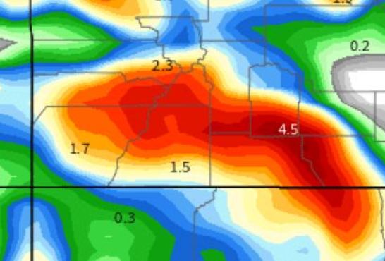
As always, these maps are showing the total liquid-equivalent precipitation in inches. I zoomed in on the maps today to show you greater detail. For those of you who are new, I usually do this the day that the storm is set to arrive.
Canadian

![]()
German

![]()
NOAA NBM

![]()
Euro


GFS latest run
GFS 6 hours earlier–amazingly consistent.

My next update will be around noon. My preliminary forecast will be later this afternoon. Thanks for following and supporting the site!