There are now 30 chances to win cash or prizes in the 2022 Contest this year. If you have not checked it out yet click here: 2022 Contest Updated 10/30/22
11/1/22 Tuesday 11 am
This extended model has been very successful this year, it helped me greatly with the monsoon forecast earlier this year. It continues to advertise below-average temperatures and above-average precipitation through mid-December, which is great news!
It is also important to note that this model has a warm and dry bias to it. It will likely verify colder and wetter throughout our forecast area than what it shows here.
Here are below-average temperature anomalies. The numbers indicate how many degrees below average the overall temperatures are forecast to be.
This is now through November 30th

Through December 15th

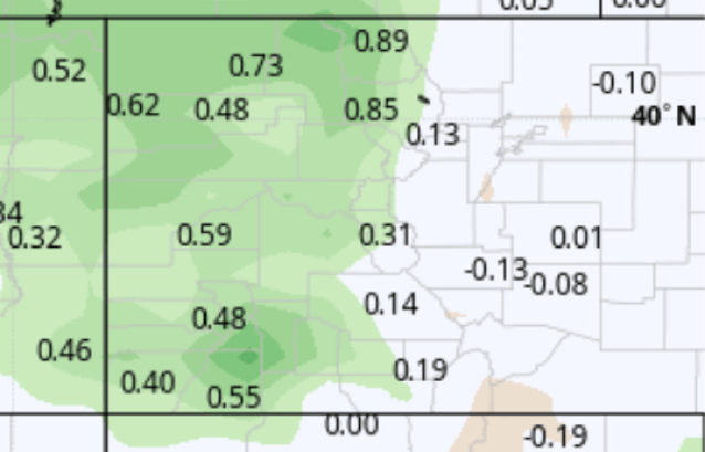
Here are the precipitation anomalies. This shows the amount of liquid precipitation in inches above average for the periods.
Through November 30th

Through December 15th
According to this latest run, the first half of December will be very wet.
Here is the snowfall forecast through December 15th.

Next is the snowfall forecast for all of our regional airport locations in Southwest Colorado. The graph at the bottom of the images shows the average output of 50+ model members. The forecast is in the light blue bar graph bottom labeled “mean”
Telluride (TEX)

In this case, the snowfall forecast is for 38 inches at Telluride airport by December 15th.
Pagosa (Stevens field)

Durango (DRO)

Montrose (MTJ)

Cortez (CEZ)

I will post a couple of updates on Wednesday. Thanks for following and supporting the site and the contest!
Click here to donate for a chance to win
If you prefer to donate with Venmo: @Jeff-Givens-11
Click here to submit a weather report or question
Send your weather videos to: durangoweatherguy@gmail.com