Wolf Creek Pass Closure Alert–Sunday Morning!

12/31/22 Saturday 6:15 pm

― WINTER MAINTENANCE OPERATIONS ALERT ―
Sat., Dec 31, 2022

Safety closure set for US 160 Wolf Creek Pass on New Year’s morning

CDOT will perform winter maintenance operations on US 160 Wolf Creek Pass tomorrow, Sun., Jan. 1. Crews will close the highway and begin work at 5:30 a.m. Westbound traffic will be stopped just west of the ski area near the pass summit (MP 168) and eastbound traffic will be stopped near Treasure Falls (MP 158).

Travelers can expect a lengthy delay of one hour or more. However, please be aware this delay may be extended should unusual circumstances arise. Regional travelers should plan ahead and allow for extra travel time. Travelers may also consider arriving at the closure points before 5:30 a.m. to avoid the lengthy closure. Visit COtrip.org for highway closure information and updates.

Thanks for following and supporting the site!

Click here to donate 

If you prefer to donate with Venmo: @Jeff-Givens-11

Click here to submit a weather report or question

Send your weather videos to:  durangoweatherguy@gmail.com

Big snow for the local resorts on the way!

12/31/22 Saturday 3:30 pm

Had another power outage this morning, things could get really interesting the next couple of days if they had that much trouble with the 4 inches that fell in most areas overnight…

For areas below 8,000 feet, the jury is still out. It’s going to be all about the temperatures and when the heavy precipitation starts. Although light snow may redevelop overnight, the big push will come later on Sunday.

There is no doubt the leading edge of moisture arrived early this morning. Nothing like a little light snow mist to get your day going!  As I mentioned, light snow may redevelop tonight into tomorrow morning, but I do not expect the bigger push to start until after 2 pm on Sunday.

Fortunately, that gives me a few more model cycles to figure out the lower and mid-elevation forecasts. At this point, I would love to see the storm slow down a little more and come arrive Sunday evening. This is entirely possible. It appears at this moment that the heaviest snow will fall Sunday evening through Monday late morning. Some models are showing left-overs occurring throughout the entire forecast area through Tuesday night. The snow will start out wet and heavy, but will transition to fluffier snow as the cold air arrives.

By the time the snow stops completely late Tuesday or Wednesday I expect the following additional totals in the higher elevations:

Purgatory, Wolf Creek, and Cola Bank Pass:  24 to 30 inches

Telluride, Silverton, Rico, Molas, and Red Mountain Passes:  16-20 inches

I will post my snowfall forecasts for other areas on Sunday, until then here are some model runs to check out. These are total snowfall in inches before melting and compaction.

GFS

Canadian

European

NBM latest


NBM 6 hours earlier

Interesting fluctuations in the high-resolution models. I have gotten several emails from app watchers remarking about how their forecasts keep changing. There is your explanation.

While I was typing that, the NWS issued a Winter Weather Advisory for the lower elevations:

COZ021>023-011400-  
/O.EXB.KGJT.WW.Y.0030.230102T0100Z-230102T1900Z/  
FOUR CORNERS/UPPER DOLORES RIVER-ANIMAS RIVER BASIN-  
SAN JUAN RIVER BASIN-  
INCLUDING THE CITIES OF CORTEZ, DOVE CREEK, MANCOS, DURANGO,   
BAYFIELD, IGNACIO, AND PAGOSA SPRINGS  
151 PM MST SAT DEC 31 2022  
  
...WINTER WEATHER ADVISORY IN EFFECT FROM 6 PM SUNDAY TO NOON MST  
MONDAY...  
  
* WHAT...SNOW EXPECTED. TOTAL SNOW ACCUMULATIONS OF 3 TO 6 INCHES  
  WITH LOCALLY HIGHER AMOUNTS UP TO 9 INCHES IN THE FOOTHILLS.  
  
* WHERE...FOUR CORNERS/UPPER DOLORES RIVER, ANIMAS RIVER BASIN   
  AND SAN JUAN RIVER BASIN.  
  
* WHEN...FROM 6 PM SUNDAY TO NOON MST MONDAY.  
  
* IMPACTS...PLAN ON SLIPPERY ROAD CONDITIONS. PATCHY BLOWING SNOW  
  COULD SIGNIFICANTLY REDUCE VISIBILITY.

No changes for the higher elevations.

Their discussion is not out yet, but I suspect they wanted to post something, and this is a start. If colder temperatures verify or the storm comes in a little later and stronger, they will easily be able to upgrade the advisory to a warning.

I plan to check in tomorrow morning, but I may not post my forecasts until later in the day. Thanks for following and supporting the site!

Click here to donate 

If you prefer to donate with Venmo: @Jeff-Givens-11

Click here to submit a weather report or question

Send your weather videos to:  durangoweatherguy@gmail.com

Friday afternoon short-term update.

12/30/22 Friday 4:15 pm

There are some discrepancies among the models regarding the main AR event, it will be delayed and now should begin on Sunday. Meanwhile, we will have a localized snow event develop tonight into tomorrow that is completely separate from the main storm. This leads me to an odd forecast for tonight through Saturday afternoon, ultimately, I hope it will work out in our favor because of the “cooler effect” (snow on the ground) that I talked about in my morning update. I am going to let the models get better organized before delving into my forecasts for the AR event. I will cover those tomorrow afternoon.

For tonight expect snow to develop across the forecast area. I expect 1 to 3 inches at or below 6,500 feet. 3 to 6 inches of snow across the mid-elevations, as well as Silverton and Wolf Creek (I told you it was an odd forecast). 4 to 8 inches of snow should fall at Telluride, Rico, Mayday, Purgatory, and the 550 passes. This is just through Saturday afternoon, let’s call it 4 pm. I originally wrote this at 1 pm, some of the afternoon models have trended higher with the amounts. We’ll see.

Thanks for following and supporting the site!

Click here to donate 

If you prefer to donate with Venmo: @Jeff-Givens-11

Click here to submit a weather report or question

Send your weather videos to:  durangoweatherguy@gmail.com

Friday Morning Update–Long term Winter Storm Warnings issued!

12/30/22 Friday 8:20 am

For today, expect on-and-off snow showers to redevelop this afternoon through Saturday morning. Another 1 to 4 inches can be expected in the lower and mid-elevations before the big system approaches on Sunday. See below for the accumulations in the higher elevations.

The NWS did something they almost never do and I like the way they are thinking. Normally, they pinpoint the heaviest window of precipitation and issue an advisory or warning for that period.

As I alluded to the last couple of days, in the higher elevations it is going to be difficult to tell when one disturbance leaves and another system arrives because it may not stop snowing, or there may be just a brief lull before it starts again.

So the NWS, recognizing this, decided to issue a long-term Winter Storm Warning beginning this evening at 6 pm and ending at 6 pm on Monday. One thing I need to mention, just because as issued the Winter Storm Warning ends on Monday at 6 pm does not mean the Winter Storm Warning conditions will stop then. I expect it to continue snowing through Tuesday and maybe Wednesday.

COZ019-301830-  
/O.UPG.KGJT.WS.A.0015.221231T0700Z-230102T2100Z/  
/O.EXB.KGJT.WS.W.0014.221231T0100Z-230103T0100Z/  
SOUTHWEST SAN JUAN MOUNTAINS-  
INCLUDING THE CITIES OF SILVERTON, RICO, AND HESPERUS  
325 AM MST FRI DEC 30 2022  
  
...WINTER STORM WARNING IN EFFECT FROM 6 PM THIS EVENING TO 6 PM  
MST MONDAY...  
  
* WHAT...HEAVY SNOW EXPECTED. TOTAL SNOW ACCUMULATIONS OF 1 TO 2  
  FEET WITH LOCALLY HIGHER AMOUNTS UP TO 3 FEET POSSIBLE. WINDS   
  GUSTING AS HIGH AS 35 MPH.  
  
* WHERE...SOUTHWEST SAN JUAN MOUNTAINS.  
  
* WHEN...FROM 6 PM THIS EVENING TO 6 PM MST MONDAY.  
  
* IMPACTS...TRAVEL COULD BE VERY DIFFICULT TO IMPOSSIBLE. PATCHY   
  BLOWING SNOW COULD SIGNIFICANTLY REDUCE VISIBILITY, ESPECIALLY   
  ON RIDGE TOPS.


COZ017-018-301830-  
/O.UPG.KGJT.WS.A.0015.221231T0700Z-230102T2100Z/  
/O.EXB.KGJT.WS.W.0014.221231T0100Z-230103T0100Z/  
UNCOMPAHGRE PLATEAU AND DALLAS DIVIDE-  
NORTHWEST SAN JUAN MOUNTAINS-  
INCLUDING THE CITIES OF RIDGWAY, GLADE PARK, TELLURIDE, OURAY,   
AND LAKE CITY  
325 AM MST FRI DEC 30 2022  
  
...WINTER STORM WARNING IN EFFECT FROM 6 PM THIS EVENING TO 6 PM  
MST MONDAY...  
  
* WHAT...HEAVY SNOW EXPECTED. TOTAL SNOW ACCUMULATIONS OF 10 TO 20  
  INCHES, WITH LOCALLY HIGHER AMOUNTS UP TO 30 INCHES POSSIBLE.   
  WINDS GUSTING AS HIGH AS 35 MPH.  
  
* WHERE...UNCOMPAHGRE PLATEAU AND DALLAS DIVIDE AND NORTHWEST   
  SAN JUAN MOUNTAINS.  
  
* WHEN...FROM 6 PM THIS EVENING TO 6 PM MST MONDAY.  
  
* IMPACTS...TRAVEL COULD BE VERY DIFFICULT TO IMPOSSIBLE. PATCHY   
  BLOWING SNOW COULD SIGNIFICANTLY REDUCE VISIBILITY, ESPECIALLY   
  ON RIDGE TOPS.

Pueblo NWS apparently did not get let in on this, they are not going to issue a Winter Storm Warning for Wolf Creek until Saturday, but I expect 2 to 3 feet there as well.

Just to repeat what I said earlier, just because the Warning expires on Monday, does not mean the storm will be over on Monday!

Noticeably absent from warnings are the lower and mid-elevations. There is a good reason for that. This is another warm-based Pacific system. Known these days as an AR, back in the day it was called “Pineapple Express”–I guess they had to change the name to AR after a stupid movie with the same name came out.

Anyway, to complicate matters further, there is snow on the ground in many areas where there was no snow for the first storm. Why does that matter? Think of a cooler, how long will food or drink stay cold without ice in the cooler? In these areas, the cooler has ice in it (snow is on the ground), this creates an inversion where the air closer to the surface is colder than the air above it. This can create an event called overrunning where light rain turns to snow before it hits the ground.

The weather models don’t handle this well, and they tend to forecast temperatures too high, so they under-forecast snow and over-forecast rain in these lower elevations.

I would be very surprised if we do not see Winter Weather Advisories or Winter Storm Warnings issued later today or tomorrow for the lower elevation areas beginning Saturday night or Sunday morning.

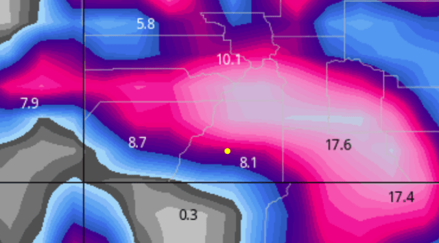
Here are the latest model runs showing total liquid-equivalent precipitation in inches. To be consistent with the Winter Storm Warning, these totals are only through Monday evening, so I expect the final totals to possibly be higher.

European

GFS

NOAA high-resolution NBM

Canadian

This afternoon I will issue my preliminary forecast for the higher elevations. I am going to hold off on my lower and mid-elevation forecast until Saturday late afternoon. Thanks for following and supporting the site!

Click here to donate 

If you prefer to donate with Venmo: @Jeff-Givens-11

Click here to submit a weather report or question

Send your weather videos to:  durangoweatherguy@gmail.com

Red Mountain Pass Closure

12/30/22 Friday 6:15 am

I will have my normal update out later this morning, but I wanted to mention that 550 will be closed from Silverton to Ouray for avalanche mitigation, I do not yet know the time of the closure but I wanted to get that information out to everyone. Please share this with anyone that you know will be affected. I also heard the current plan is to close Wolf Creek on Monday for maintenance but that is highly subject to change based on conditions.

My normal morning update should be out around 8 am at the latest.

Thanks for following and supporting the site!

Click here to donate 

If you prefer to donate with Venmo: @Jeff-Givens-11

Click here to submit a weather report or question

Send your weather videos to:  durangoweatherguy@gmail.com

More snow over the next 48 hours, then a lot more snow!

12/29/22 Thursday 1:30 pm

It’s still snowing at Wolf Creek, it will be interesting to see how far they pull ahead in their snow totals today and tomorrow. Speaking of today and tomorrow, light snow showers will develop elsewhere this evening and continue on and off through tomorrow morning or so. Again, I am not sure that nature’s snow-making machine will shut down at Wolf Creek.

For tonight and tomorrow, I do not expect any major accumulations, probably 1 to 3 inches across the lower and mid-elevations. Of course, I did not expect the snow squalls to develop as much as they did last night, so we will see. We may see an upside surprise in the higher elevations of 5 inches, and more than that is possible at Wolf Creek.  Snow will redevelop across the forecast area again late Friday into Saturday, I will talk more about those totals tomorrow.

The big picture is more important in this case. Heavier snow will move into the area on Sunday and Monday.

Here are the latest forecast totals for liquid precipitation between now and Wednesday morning (in inches).

European

NOAA High-resolution NBM model

GFS

Canadian

My next update will be Friday morning. Thanks for following and supporting the site!

Click here to donate 

If you prefer to donate with Venmo: @Jeff-Givens-11

Click here to submit a weather report or question

Send your weather videos to:  durangoweatherguy@gmail.com

The Storm That Keeps On Giving–But We Are Just Getting Started

12/29/22 Thursday 8:10 am

I have not yet caught up on emails and it may take a while. Yesterday’s outages put me behind. Snow will continue across northern portions of the forecast area before subsiding this morning. Later today, snow showers are expected to redevelop across the entire forecast area. The snow should continue into the day on Friday before s a lull. Then another system moves in late Friday into Saturday, then Saturday night through Monday… Do you see where I am going with this? The switch to winter has definitely been turned on.

I know there are a lot of people who are planning on going over Wolf Creek in the coming days. For those of you who fear winter driving conditions, I do not have good news for you. Wolf Creek was slightly behind some of the totals for the other areas yesterday, but that has changed.

The storm total so far is 16 inches up there and it is still snowing. Based on the weather models I have looked at, I am not sure that it will ever stop snowing during this storm cycle. There could be periods of lighter snow between the periods of heavy snow. CDOT will likely choose the periods of lighter snow to close for maintenance operations. I will try to find out more about this for my afternoon update. All said and done 3 to 4 additional feet will likely fall at Wolf Creek by next Tuesday morning.

It looks like the snow has stopped for a while at Purgatory, they are leading the pack so far with 20 inches. Telluride is up to 12 inches and as I mentioned 16 at Wolf Creek. As far as other totals go, I don’t know if I will have time to compile a list, but here at DWG HQ in Durango West 2, we ended up with 15 inches total. This does not account for what melted yesterday. We had 6 inches last night that I have to remove this morning. There were widespread reports of 6 to 10-inch totals across the lower elevations with roughly 4 inches of that coming last night.

My number one concern is travel over the passes for the next 5 days. Storm cycles have a cumulative effect on driving conditions. Most of the snow yesterday was dense. Last night, later today, and tomorrow the snow will be powdery. By Saturday, some models are showing a return to dense snow. That makes for very dangerous avalanche conditions.

My next update will be early afternoon. Thanks for following and supporting the site!

Click here to donate 

If you prefer to donate with Venmo: @Jeff-Givens-11

Click here to submit a weather report or question

Send your weather videos to:  durangoweatherguy@gmail.com

Important Info On 550 Travel

12/28/22 Wednesday 5:30 pm

Expect delays on US 550 Coal Bank and Molas Passes tomorrow morning

CDOT will perform winter maintenance operations on US 550 between Durango and Silverton tomorrow morning. Crews will begin work at 6:30 a.m., triggering several slide paths and clearing snow on Coal Bank and Molas passes. Travelers can expect lengthy delays of an hour or more and should allow for extra travel time between Durango and Silverton. Motorists may also consider traveling before highway work begins. The operations will take place through much of the morning.

With the prolonged storm system expected to remain in the area through early next week, travelers should be aware that additional maintenance work and safety closures may be implemented on southwest Colorado mountain passes over the next few days.

Hopefully, my next update will be Thursday morning. Thanks for following and supporting the site!

Click here to donate 

If you prefer to donate with Venmo: @Jeff-Givens-11

Click here to submit a weather report or question

Send your weather videos to:  durangoweatherguy@gmail.com

Better Late Than Never

12/28/22 Wednesday 5 pm

I should know better than to promise frequent updates throughout a storm. I have had several on-and-off power outages and internet outages. The last one was for 3 hours. I am back online. Basically, the storm stalled, fooling all of the surface map algorithms and hand-drawn analysis, typical. Snow will fall on and off through the evening hours, I don’t expect significant accumulations but we never know. The heaviest snow tonight should fall in the northern portions of the forecast area: Telluride, Red Mountain, and Ouray. We have more snow on the way, in the coming days. I will talk more about that tomorrow.

Hopefully, my next update will be Thursday morning. Thanks for following and supporting the site!

Click here to donate 

If you prefer to donate with Venmo: @Jeff-Givens-11

Click here to submit a weather report or question

Send your weather videos to:  durangoweatherguy@gmail.com

Wednesday Early Morning Update

12/28/22 Wednesday 5:15 am

So far, for the most part, the storm is about as expected, maybe even better. I measured 5 inches of wet heavy cement-like snow at my house at 3 am. Purgatory reported 8 inches at 5 am. Telluride so far has had only 4 inches (5 am). It looks like very heavy snow is falling at Wolf Creek.  Models indicate the precipitation should ramp up by mid to late morning, perhaps earlier My main concern continues to be the temperatures.

Heavy snow can lower temperatures and lower snow levels. We may need that to happen for the lower elevations to see decent accumulations. With the main storm energy way back near Las Vegas, it is far too early to judge this storm.

Here is the current surface map. It should update around 7 or 8 am.

I will be updating throughout the day. Thanks for following and supporting the site!

Click here to donate 

If you prefer to donate with Venmo: @Jeff-Givens-11

Click here to submit a weather report or question

Send your weather videos to:  durangoweatherguy@gmail.com