Afternoon Showers Return

7/10/22 Sunday 4:45 am
In my last post, I mentioned that showers could return to the forecast area as early as Sunday or Monday afternoon. This does look to be the case, the models continue to show things falling back into place to slowly open back up the monsoon tap from the southwest.
For today and tomorrow, isolated to scattered storms will favor the higher elevations by midday and then move off the mountains to mid and lower elevation areas throughout the afternoon. Storm motion will be slow and erratic, so it is impossible to predict where the storms will set up and end up. Precipitable water values (PWAT) will climb to 140% to 160% of the climatological average (climo) for this date.
Showers will become more widespread on Tuesday and Wednesday as deeper moisture works into the forecast area. PWATs will jump to 200+% of climo. This pattern looks like it will continue for the foreseeable future.
My next update will be on Tuesday.Thanks for following and supporting the site!

Click here to donate 

Click here to submit a weather report or question

Send your weather videos to:  durangoweatherguy@gmail.com

Transition Day

7/7/22 Thursday 6:45 am
Sorry for missing my update yesterday afternoon, I had more on my plate than I expected. Showers were isolated yesterday but areas that got rain did well. On Tuesday showers were pretty widespread with many areas getting 0.50-1.00+ inches. A good start to July overall. We are going to hit the pause button for most areas on the rain as high pressure builds across the western US. Afternoon higher elevation showers can never be ruled out despite the high pressure.
This is not going to be a perma-dome of high pressure like we often see in the shoulder seasons, the next trough of low pressure is already on the map and it will get rid of the high pressure by mid-next week at the latest, maybe even on Sunday afternoon or Monday.
Seasonally warm high temperatures are going to accompany this high-pressure ridge. For those of you waiting for a dry period, this is your time. Again, can’t rule out a higher elevation-based thunderstorm, but the ridge will really build in starting tomorrow. If you love hot and dry enjoy the next few days before the monsoon returns.
Thanks for following and supporting the site!

Click here to donate 

Click here to submit a weather report or question

Send your weather videos to:  durangoweatherguy@gmail.com

Moist Flow Returns

7/5/22 Tuesday 7:45 am
But will it rain? Models are very mixed when it comes to precipitation reaching the ground. For example, check out the Euro versus the GFS. These are 48-hour forecast totals.
Euro
GFS
The Canadian looks similar to the GFS, and the German looks similar to the Euro. PWAT (precipitable water values) are starting off today at 170% of climo (climatological average). These values will be approaching 200% of average as the day wears on. Therefore, I would say scattered to widespread showers seem like a good bet throughout most of the forecast area today. Scattered to isolated showers could very well develop again on Wednesday before warm dry air starts to take over the region late this week into the weekend. More on that tomorrow and Thursday.
The Euro extended model came out last night and it shows the above-average precipitation continuing across the forecast area this summer. It does show the dry air taking over by the weekend but the favorable flow will return sometime next week and we will go right back into the wet pattern.
Here are the positive precipitation anomalies for the next 30 days through August 4th. The amounts shown are not totals, they are the amounts above (or below) average for the period.
Here are the anomalies through August 11th, indicating a wet start to August for the southern portions of the forecast area.
My next update will be Wednesday afternoon and I will talk more about the drier weather that is on the way.
Thanks for following and supporting the site!

Click here to donate 

Click here to submit a weather report or question

Send your weather videos to:  durangoweatherguy@gmail.com

Playing Catch-Up

7/3/22 Sunday 8:10 am
I am feeling better, but I am not 100%  I still have not worked out, maybe tomorrow. There are a lot of unexpected cobwebs with this crap. I am going to leave it at that.
I am going to do my best to jump right back into the current and future weather. I had plans for a June recap, but rather than focus my energy on what happened I am going to try to focus on what’s next. Late Monday/Tuesday morning the new long-term Euro will be out so I can get a good look into mid-August to see what is in store for us. Both the Euro 46 day and the Euro seasonal were instrumental in my early prediction of an above-average monsoon season months ago.
At least at my house, the rain overnight and this morning were very tranquil. It is sleeping rain in my book. The cool temps and humidity were quite refreshing. Most of the models show the showers continuing scattered at times throughout the day.
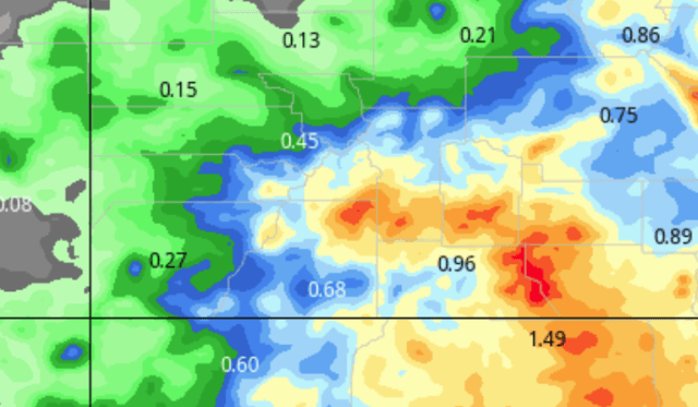
Here are the latest runs showing the totals for the next 24 hours (ending Monday 6 am).
GFS
Euro
Canadian
German
Pretty good consistency overall, the German has a bit loftier expectations. Given the precipitable water values (PWAT) now and throughout the day, I would not be dismissing higher totals than what is currently being forecasted.
Remember, PWAT is the amount of precipitation available to fall in a virtual column if it fell all at once. In a nutshell, look at the atmosphere like a sponge, and you wrang all of the moisture out of the sponge here is how much rain would be available to fall.
Here is the PWAT forecast through Monday at 6 am.
These values represent 170% to 200+% of the climatological average for today.
On Monday, showers should be more isolated in nature. Tuesday it looks like we will return to more widespread showers. I don’t want to get too far ahead of myself right now, but some models are suggesting that we will be transitioning into a slightly drier pattern by late next week. I know there are some folks who really hope this will happen. No promises, but I am keeping my eye on it.
The radar is back as I am sure many of you noticed. There were no upgrades that would benefit our area. I was emailing back and forth with a contact at NWS Grand Junction a while back. They are looking forward to our new radar as much as we are. To answer your question, I do not have any information as to the latest projected date it will be up and running, but I will email and get an update and let everyone know this week.
Thanks for all of the nice emails over the last week, and as always, thanks for following and supporting the site!

Click here to donate 

Click here to submit a weather report or question

Send your weather videos to:  durangoweatherguy@gmail.com


Brief Thursday Update

6/30/22 Thursday 10 am

Showers are likely to develop this afternoon. We are back into a favorable position for monsoonal moisture transport. It looks like showers will be more widespread Friday, Saturday, and Sunday. More than likely Monday as well. I did not do a deep dive on the models but they seem to be in good agreement for the next few days.

I underestimated how the virus would affect me, and overestimated my ability to keep a regular schedule. I think the worst is over but I am still struggling more than I ever thought I would. Thanks for the emails, I have not gotten to all of them. Hopefully, I will be able to dig back into the weather this weekend.

Thanks for following and supporting the site!

Click here to donate 

Click here to submit a weather report or question


Monday Evening Update

So far most of the showers across the forecast area have not developed. The dewpoints are high across the forecast area. I am doing my best to track everything. I apparently have Covid. I have had 3 positive tests. My wife is still negative. I have had a moderate fever and I have chest congestion. No big deal. I still plan on light to moderate exercise tomorrow.
I will try to do a model update tomorrow.
Thanks for following and supporting the site!

Click here to donate 

Click here to submit a weather report or question

Send your weather videos to:  durangoweatherguy@gmail.com

Can Rain Be Boring?

6/27/22 Monday 6:45 am
I suppose rain could be boring after a while. While not necessarily boring, I have heard from several folks wanting to cut hay and are hoping for a clue as to when we could string a few dry days together to do that. Unfortunately, I am not seeing anything like that from the models. There may be a day here or there, maybe Wednesday through Thursday morning, but no multiple days as far as I can see.
The other problem is a lot of the convective showers are very difficult to predict. Speaking of that, convection should peak between 1 and 4 pm today. The air is slightly drier than yesterday but afternoon showers drifting off of the higher terrain today seem like a good bet.
If you like the afternoon showers we are going to see plenty more of them. As I  mentioned we may see some lulls here and there, but I do not see an end to this pattern. Early indications are that we are in for a wet weekend, that could change between now and then. I will be keeping an eye on it.
Yesterday, I had almost given up on the idea of rain. Lately, the models had been focusing on the heavy precipitation that has been nearly non-stop along a line from Tucson to Santa Fe. Later in the afternoon some of that moisture drifted north and unleashed moderate to very heavy amounts of rain across the forecast area.
Most of the areas that got rain yesterday received 0.50 to 1.25 inches. But I also saw a couple of anomalies in excess of 2 inches, 3 inches, and one near 4-inch report. For those of you not used to getting a lot of rain, there is some hope. I got a report from 7 miles WSW of Cortez where 1.2 inches fell.
Thanks for the reports, pictures, and videos. If you are going to shoot some video shoot it horizontally, and don’t be afraid to let it run a while. If it is too long I can always edit it.
Thanks for following and supporting the site!

Click here to donate 

Click here to submit a weather report or question

Send your weather videos to:  durangoweatherguy@gmail.com

Rain More Rain And Then Some Rain

6/25/22 Saturday 7 am
A few sneaky showers developed yesterday. The models did a poor job of picking up on them. The dewpoints are slightly lower this morning to start the day but moisture will be on the increase as we approach the afternoon. Isolated showers will develop once again, it is difficult to predict exactly where.
Sunday will bring more widespread showers. The models are not in agreement with the start and stop times. Most of the models show showers continuing on Monday. The Euro is the outlier bringing showers to end by Monday morning. Based on that I put the maps in motion using the GFS model, it has been doing better with the afternoon showers lately and has been more consistent from run to run for the last day compared to the Euro. These are 3-hour increments starting at noon today and ending Tuesday at 6 am.
Here are the forecast amounts from the models during that same time period. There is good consistency in some areas and poor consistency in others. There is definitely an easterly bias for the heaviest precipitation.
Euro
NOAA’s WPC
NOAA’s NBM
Canadian
GFS
My next update will be on Sunday. Thanks for following and supporting the site!

Click here to donate 

Click here to submit a weather report or question

Send your weather videos to:  durangoweatherguy@gmail.com

Friday Update A July Preview

6/24/22 Friday 6:30 am
A few nice rounds of thunderstorms made their presence felt across the area yesterday afternoon. In the areas that did get rain 0.25 to 0.60 inches of rain was common. A note about rain totals, I am going to post monthly totals next Friday, July 1st.  It is going to be pretty incredible because I have two areas that are already at historic levels for June–around 6 inches! One of them is Gem Village.
I was in downtown Durango securing weekend rations and as usual, I had to go to four (of four) stores and I still did not mark everything else off the list. When it first started raining it literally felt like Orlando, Florida in the summertime with the heat and humidity. Fortunately, when I got back home we had some heavy rain and the temperature plummeted, which was a nice relief. I have decided I like the sunny morning/rainy afternoon set-up. I have been spending a lot of time outdoors so it is nice to have it sunny for part of the day.
Showers today may develop but should be highly isolated. More storms will fire Saturday afternoon, still isolated, but more widespread than today. Sunday still looks like rain will fall most of the day and be more widespread, with some nice wetting rains throughout the forecast area. This will carry on through Monday.
Late yesterday, the Euro extended came out and as I expected, the good news does not end anytime in the foreseeable future.
Here are the extended totals for now through the end of the month.
Here is a look at now through the end of July
Here is the positive anomaly for July. This shows the excess rainfall amount above average for July.
 I have really enjoyed some of the still pictures people have sent me. I am still looking forward to seeing some videos. I will be shooting some myself soon, I am waiting for some equipment that is supposed to be here on Tuesday.
I wanted to shoot video yesterday because it was raining as hard as I have seen it in 5 years (but only for 15 minutes). I actually do have that video from August 2017, I will be re-posting that when I launch the channel. We got 2.3 inches of rain in less than an hour and the streets turned to streams in my subdivision. I actually got some regional and national views on television with that one.
I will post again on Saturday and see if I can refine the Sunday forecast a little clearer. Thanks for following and supporting the site!

Click here to donate 

Click here to submit a weather report or question

Send your weather videos to:  durangoweatherguy@gmail.com

Wednesday Afternoon Update

6/22/22 Wednesday 1:30 pm
Showers should build in later in the day and throughout the evening. It is challenging to have the Grand Junction Radar down. We complain about it, but it is certainly better coverage than we get from ABQ.
It still looks like the southern portions of the forecast area will be favored tonight into tomorrow morning. Afternoon storms should break back out Thursday and Friday. It seems every time I post the short-term totals something changes. Some of the models changed quite a bit in 12 hours. I learned my lesson, again.
One thing that did not change is an emphasis on widespread heavier rain throughout the day on Sunday. I am going to let whatever happens in the short term happen. I will post again on Friday and we will take a better look at how June ends and July begins.
I am getting a lot of positive feedback about my upcoming YouTube weather video channel. As I said it will probably be a little while before I have enough content to launch it. Hail storms, lightning, heavy rain, strong winds, and heavy flowing streams all make great content. In the coming days, I would love for people to send me what they see. Before sending it make sure you are comfortable with me sharing it publicly. For best results, try to take the video horizontally (full screen). Try for at least 30 to 60 seconds per clip, I can stitch together pieces if necessary. You can send the videos to me at durangoweatherguy@gmail.com  Feel free to use my personal email address as well if you already have that saved in your address book.
Thanks for following and supporting the site!

Click here to donate 

Click here to submit a weather report or question

Send your weather videos to:  durangoweatherguy@gmail.com