Friday Afternoon Update–Winter Storm Watches Issued

10/21/22 Friday 3:45 pm
Before I begin, I updated the prize list for the 2022 Contest. If you have not had a chance to check it out click here: 2022 Contest The Largest Ever–Updated 10/21/22
The NWS ended up going the Winter Storm Watch route today. We will see how they handle the wording tomorrow. It is apparent that the NWS favors the European model for this storm.
Grand Junction
URGENT – WINTER WEATHER MESSAGE
NATIONAL WEATHER SERVICE GRAND JUNCTION CO
310 PM MDT FRI OCT 21 2022

COZ004-009-010-012-013-018-019-UTZ023-221015-
/O.NEW.KGJT.WS.A.0008.221023T0300Z-221024T1200Z/
ELKHEAD AND PARK MOUNTAINS-GRAND AND BATTLEMENT MESAS- GORE AND ELK MOUNTAINS/CENTRAL MOUNTAIN VALLEYS- WEST ELK AND SAWATCH MOUNTAINS-FLAT TOPS-
NORTHWEST SAN JUAN MOUNTAINS-SOUTHWEST SAN JUAN MOUNTAINS-EASTERN UINTA MOUNTAINS-INCLUDING THE CITIES OF COLUMBINE, HAHNS PEAK, TOPONAS, ASPEN,
VAIL, SNOWMASS, CRESTED BUTTE, TAYLOR PARK, MARBLE, BUFORD, TRAPPERS LAKE, TELLURIDE, OURAY, LAKE CITY, SILVERTON, RICO, HESPERUS (MAYDAY) , MANILA, AND DUTCH JOHN
310 PM MDT FRI OCT 21 2022

…WINTER STORM WATCH IS IN EFFECT FROM SATURDAY EVENING THROUGH LATE SUNDAY NIGHT…

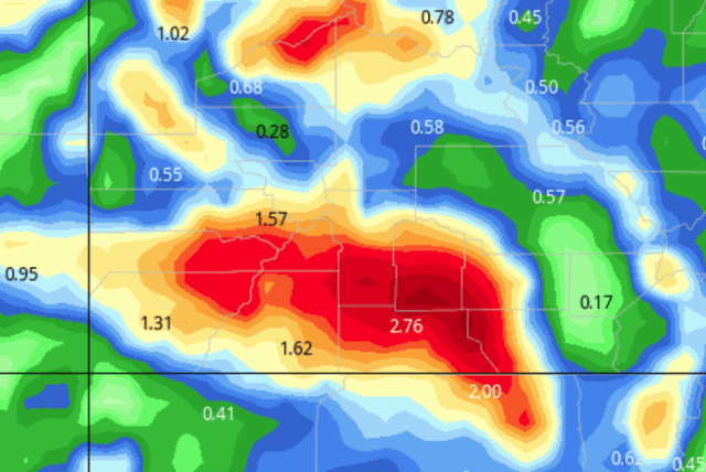
* WHAT…HEAVY SNOW IS POSSIBLE. TOTAL SNOW ACCUMULATIONS OF 7 TO 14 INCHES WITH LOCALLY HIGHER AMOUNTS POSSIBLE. WINDS COULD GUST
AS HIGH AS 55 MPH.

* WHERE…PORTIONS OF NORTHWEST, SOUTHWEST AND WEST CENTRAL COLORADO AND NORTHEAST UTAH.

* WHEN…FROM SATURDAY EVENING THROUGH LATE SUNDAY NIGHT.

* IMPACTS…TRAVEL COULD BE VERY DIFFICULT TO IMPOSSIBLE. PATCHY BLOWING SNOW COULD SIGNIFICANTLY REDUCE VISIBILITY, ESPECIALLY ON RIDGE TOPS. STRONG WINDS COULD CAUSE TREE DAMAGE.

Pueblo (Wolf Creek)

URGENT – WINTER WEATHER MESSAGE
NATIONAL WEATHER SERVICE PUEBLO CO
307 PM MDT FRI OCT 21 2022

COZ060-066-068-220515-
/O.NEW.KPUB.WS.A.0009.221023T0300Z-221024T1200Z/
EASTERN SAWATCH MOUNTAINS ABOVE 11000 FEET-
LA GARITA MOUNTAINS ABOVE 10000 FEET-
EASTERN SAN JUAN MOUNTAINS ABOVE 10000 FEET-
307 PM MDT FRI OCT 21 2022

…WINTER STORM WATCH IN EFFECT FROM SATURDAY EVENING THROUGH LATE SUNDAY NIGHT…

* WHAT…HEAVY SNOW POSSIBLE. TOTAL SNOW ACCUMULATIONS 8 TO 14 INCHES MOUNTAINS. WINDS COULD GUST AS HIGH AS 60 MPH.

* WHERE…EASTERN SAWATCH MOUNTAINS ABOVE 11000 FEET, LA GARITA MOUNTAINS ABOVE 10000 FEET AND EASTERN SAN JUAN MOUNTAINS ABOVE 10000 FEET.

* WHEN…FROM SATURDAY EVENING THROUGH LATE SUNDAY NIGHT.

* IMPACTS…TRAVEL COULD BE VERY DIFFICULT. SNOW AND BLOWING BLOWING SNOW COULD SIGNIFICANTLY REDUCE VISIBILITY.

Not a lot of model changes since the overnight runs. That is good news. We don’t want to see big model moves the day before the storm arrives.
NBM liquid
GFS liquid
Remember, the GFS under-forecast in the lower elevations.
GFS snow
The model also has a built-in warm bias, sometimes as high as 5-7 degrees, this affects snow output.
Euro snow
Notice the Euro shows all snow at Telluride and Wolf Creek
Canadian liquid
Canadian snow
My next update will be on Saturday morning. Thanks for following and supporting the site and the contest!

Click here to donate for a chance to win

If you prefer to donate with Venmo: @Jeff-Givens-11

Click here to submit a weather report or question

Send your weather videos to:  durangoweatherguy@gmail.com

2022 Contest The Largest Ever–Updated 10/21/22

Background

I had several emails in the spring asking me if I was going to sponsor another contest this year. I am holding a contest this year, I just wanted to hold off until this fall to do so.
If you are new to the site this is something I did in the spring of  2020 and 2021. This year is going to be the biggest ever. There is going to be more prize money than in the previous two contests. I am also going to match the prize money by donating $2000  to local charities in SW Colorado.  I am still researching charities but they will be various food banks and charities that benefit children during the holidays. If you donated on September 1st or later you are already in. Active monthly donors at the time of the drawing are also eligible. The cash drawings will be on Friday, December 9th. The charitable contributions will be made on or before December 6th. I will announce all of the prize winners after I contact them.
Merchants are welcome to donate goods or services. I am not going actively solicit any businesses this year, it has been a difficult year for many so I do not want to put any pressure on anyone.

Prize List–Updated

$2000 in cash prizes will be distributed as follows:  Two $25o prizes, four $150 prizes, four $100 prizes, four $75 prizes, and four $50 prizes. The good folks at Eolus wanted to participate again this year. They are adding four $50 gift cards to the prize list. PJ’s Market has also kindly come back to support the contest, they are donating two $50 gift cards. The next prize is something unlike we have ever had before. I have a follower who has a large ranch south of Pagosa. He has 1.75 miles of private riverfront property near where the Navajo and San Juan Rivers meet. He is arranging three one-day fishing trips accompanied by a guide. He told me that the guides love to fish the property because it has not been open to the public for over 12 years! The winners will have until June 15th, 2023 to enjoy their prize.
Cash prizes will be distributed the same way in which the entries were made unless you let me know otherwise. Winners will be contacted via email before I publish the names.  The link at the bottom is for Paypal and credit/debit cards. I have also included my Venmo information. If you prefer to send a check, click the blue link to contact me for that information.
Thanks for following and supporting the site!

Click here to donate for a chance to win

If you prefer to donate with Venmo: @Jeff-Givens-11

Click here to submit a weather report or question

Send your weather videos to:  durangoweatherguy@gmail.com

Friday Morning Update-Windy Turns To Wintery

10/21/22 Friday 7 am
The NWS is holding off on issuing a Winter Storm Watch until they see a couple of more model runs today. The incoming storm will meet the criteria of a Winter Weather Advisory for areas at or above 9,000 feet. However, early-season storms can be judged with looser criteria. The thinking is that people have not driven in winter conditions for a while, so they may need an extra boost to emphasize the dangerous conditions. Don’t be surprised if a Winter Storm Watch is issued that becomes a Winter Storm Warning on Saturday (even though technically, we may not meet the criteria of a Winter Storm Warning). It’s probably a good idea with all of the new people that have moved to our area and are not familiar with driving in the winter in the mountains.
I did not notice any major changes in the overnight model runs, there is better consistency among the model in their precipitation forecasts. The winds will start to pick up today as the pressure gradient tightens due to the approaching trough. This will become more pronounced throughout the day on Saturday.
Temperatures today and tomorrow will continue to be 4 or 5 degrees above average. On Sunday the high temperature will drop to 15 to 20 degrees below average for this time of year. Monday morning the temperatures will plummet to anywhere from the single digits to around 20 degrees depending on your location.
Here are the latest model runs from overnight
GFS liquid
You may notice in some of these maps I put a red dot on the liquid precipitation maps, that is where downtown Durango is.
The GFS and the Canadian are lower-resolution models. This means that during early-season Winter Storms when it does not get cold enough for all snow in the lower elevations the model struggles. It samples a large grid space and blends the terrain over a larger area. That is why the snow “falls off” the map in the lower elevations.
GFS snow
Canadian liquid
Canadian snow
Euro liquid
More often than not, I use a different model provider for the European liquid output parameter. This provider distinguishes downtown Durango from DRO. They also distinguish Wolf Creek from Pagosa. The European is higher resolution than the GFS and Canadian, but it still tends to overproduce the precipitation for Pagosa.
Euro snow
Here is the NBM National Model Blend. It is a much higher resolution model, equivalent to some of the short-term high-resolution models I use in the winter.
NBM Liquid
My next update will be this afternoon. Thanks for following and supporting the site!

Click here to donate for a chance to win

If you prefer to donate with Venmo: @Jeff-Givens-11

Click here to submit a weather report or question

Send your weather videos to:  durangoweatherguy@gmail.com

Special Weather Statement

10/20/22 Thursday 3 pm
Well, it is not a Winter Storm Watch, not yet anyway. NWS did just issue an SPS (Special Weather Statement). Based on the wording, it means that the issuance of a Winter Storm Watch or a Winter Weather Advisory is imminent. I am still thinking it will be tomorrow.

SPECIAL WEATHER STATEMENT…CORRECTED
NATIONAL WEATHER SERVICE GRAND JUNCTION CO
245 PM MDT THU OCT 20 2022

…FIRST SIGNIFICANT SNOW OF THE SEASON LIKELY FOR THE MOUNTAINS THIS WEEKEND…

COZ004-009-010-012-013-018-019-UTZ023-211300-
ELKHEAD AND PARK MOUNTAINS-GRAND AND BATTLEMENT MESAS- GORE AND ELK MOUNTAINS/CENTRAL MOUNTAIN VALLEYS- WEST ELK AND SAWATCH MOUNTAINS-FLAT TOPS-
NORTHWEST SAN JUAN MOUNTAINS-SOUTHWEST SAN JUAN MOUNTAINS- EASTERN UINTA MOUNTAINS-
INCLUDING THE CITIES OF COLUMBINE, HAHNS PEAK, TOPONAS, SKYWAY, ASPEN, VAIL, SNOWMASS, CRESTED BUTTE, TAYLOR PARK, MARBLE, BUFORD, TRAPPERS LAKE, TELLURIDE, OURAY, LAKE CITY, SILVERTON, RICO, HESPERUS, MANILA, AND DUTCH JOHN 


245 PM MDT THU OCT 20 2022

SIGNIFICANT CHANGES ARE ON THE WAY FOR THE MUCH OF THE WESTERN COLORADO MOUNTAINS AS WELL AS THE EASTERN UINTAS AS A STRONG COLD FRONT MOVES ACROSS THE REGION THIS WEEKEND. MOISTURE ACROSS THE REGION WILL INCREASE TO NEAR 200% OF NORMAL FOR LATE OCTOBER. THE FRONT WILL BEGIN TO PUSH ACROSS THE AREA ON SATURDAY RESULTING IN WIDESPREAD PRECIPITATION INTO SUNDAY. SHOWERS WILL CONTINUE INTO EARLY NEXT WEEK AS MOISTURE LINGERS ACROSS THE AREA.

THE GREATEST SNOW ACCUMULATIONS ARE EXPECTED TO OCCUR SATURDAY NIGHT AND INTO MIDDAY SUNDAY. THE MOST SNOW WILL FALL AT ELEVATIONS ABOVE 9000 FEET, THOUGH SNOW LEVELS MAY DROP TO ELEVATIONS AS LOW AS 6000 FEET ONCE COLDER AIR FILTERS INTO THE AREA. ON AVERAGE THE EASTERN UINTAS AND THE MOUNTAINS ALONG THE CONTINENTAL DIVIDE WILL SEE 5 TO 10 INCHES ABOVE 9000 FEET. LOCALLY HIGHER AMOUNTS IN EXCESS OF A FOOT WILL BE POSSIBLE. ADDITIONALLY, WIND GUSTS TO NEAR 50 MPH IN THE MOUNTAINS COULD LEAD TO REDUCTIONS IN VISIBILITY IN BLOWING SNOW.

THIS WILL BE THE FIRST SIGNIFICANT SNOWFALL FOR THE MOUNTAINS THIS SEASON. SNOW MAY LEAD TO PERIODS OF DIFFICULT TRAVEL IN THE MOUNTAINS. CONDITIONS COULD BECOME TREACHEROUS IN THE BACKCOUNTRY AND SHOULD BE TAKEN INTO CONSIDERATION FOR HIKERS, HUNTERS AND
OTHER RECREATORS.

My next update will be Friday morning. Thanks for following and supporting the site!

Click here to donate for a chance to win

If you prefer to donate with Venmo: @Jeff-Givens-11

Click here to submit a weather report or question

Send your weather videos to:  durangoweatherguy@gmail.com

Thursday Afternoon Model Update

10/20/22 Thursday 1:15 pm
It is more common than not for models to show different storm tracks in the days leading up to the arrival of the storm. Timing also starts to slow down. I have not seen big changes in the arrival time of the storm, but there was a noticeable difference from last night’s to this morning’s model runs. The Euro, Canadian, and GFS are all tracking precipitation further south. By no means a miss, just a different spread of the precipitation. As I said yesterday these could be anomalous runs and I will wait to make any changes in my thinking for at least 24 hours.
I had a strange request for the Japanese model forecast (JMA). It is not a model I use very often for precipitation. I use it more for tracking high-pressure ridges and low-pressure systems. But I will add it to the lineup.
GFS liquid
GFS snow
NOAA WPC liquid
German liquid
Japanese model JMA liquid
European liquid
European snow
Canadian liquid
Canadian snow
Unless we get an early Winter Storm Watch issuance later today, my next update will be Friday morning. Thanks for following and supporting the site!

Click here to donate for a chance to win

If you prefer to donate with Venmo: @Jeff-Givens-11

Click here to submit a weather report or question

Send your weather videos to:  durangoweatherguy@gmail.com

Thursday Morning Update

10/20/22 Thursday 6:45 am
Overnight the Euro model bounced back as I hoped it would with its forecast totals for the lower elevations. The Canadian is starting to trend lower with its forecast totals but is still the most aggressive model. The GFS is starting to funnel slightly more precipitation to the lower elevations. Overall, I like what I see. No word on any Watches or Warnings yet for the higher elevations, but they should be on the way before tomorrow afternoon.
Here are the latest model runs.
GFS liquid
GFS snow
I think the miss on the GFS is with the warmth. This model is implying some high-altitude rain or low snow-to-liquid ratios (SLR). I do not expect that will be the case.
NOAA NBM (National Blend Of Models)
Euro liquid
Euro snow
German liquid
Canadian liquid
Canadian snow
There are a couple more pleasant days left before the pattern change. Expect winds to pick up Friday afternoon and throughout the day on Saturday. Saturday will be the last warm day for the foreseeable future. The storm will start to move in very late Saturday to early Sunday morning. By Monday high temperatures will struggle to get out of the 40s in the lower elevations, with 20s and 30s for the mountains and mid-elevation areas. The next storm could arrive on Thursday.
I will do an afternoon model update later today. Thanks for following and supporting the site!

Click here to donate for a chance to win

If you prefer to donate with Venmo: @Jeff-Givens-11

Click here to submit a weather report or question

Send your weather videos to:  durangoweatherguy@gmail.com

Wednesday Afternoon Model Update

10/19/22 Wednesday 2 pm
Thanks to those who have participated in the contest. On Saturday I will update the prize list. In addition to all of the cash prizes, 9 new prizes have been donated by local businesses. If you have not checked it out yet click here:2022 Contest Overview–The Largest Ever.
If you prefer to donate using Venmo, I added that information at the bottom of the post.
Model Update
Here are the most recent model runs from the weather models we usually look at.
German liquid
Canadian liquid
Canadian snow
GFS liquid
GFS snow
Euro liquid
Euro snow
The GFS is still all over the place. As far as the Euro goes it has shifted the track in this run to more of a westerly component. This is not showing in the ensemble mean runs. I would have to see two more runs from the Euro showing the storm track change before I take it seriously. My gut tells me that this is an anomalous run, We will see.
For what it is worth, NOAA’s high-resolution NBM model is not giving a lot of weight to the GFS and Euro’s current runs.
I expect we will see some type of blanket Winter Storm Watch issued by the National Weather Service between Thursday afternoon and Friday morning.
My next update will be on Thursday morning. Thanks for following and supporting the site!

Click here to donate for a chance to win

If you prefer to donate with Venmo: @Jeff-Givens-11

Click here to submit a weather report or question

Send your weather videos to:  durangoweatherguy@gmail.com

Wednesday Update–Winter Storm On Track for Early Sunday Arrival

10/19/22 Wednesday 9 am
Thanks to those who have participated in the contest. On Saturday I will update the prize list. In addition to all of the cash prizes, 9 new prizes have been donated by local businesses. If you have not checked it out yet click here: 2022 Contest Overview–The Largest Ever

Winter Storm Update

I am getting so excited about this storm that I am waking up in the middle of the night just to check out the latest model runs. I will probably start doing afternoon model updates, no later than Thursday, if I can I will start them today.

This is a great storm to put the maps into motion. By far, the European model has been the most consistent model with this storm, so let’s take a look. This shows the condition beginning Saturday night at 6 pm and ending Monday at 6 pm.

Regional View

If you are new to all of this, green is rain, snow is blue, and the darker the shades of colors the heavier the rate of rain or snowfall. In the regional view, you can see the low pressure deepen in Utah and then arrive in an ideal position to our southwest

Local View

.There is still some disagreement among the models regarding snow levels. The European model is very aggressive at this point. The other models are hovering at or slightly below 8,000 feet towards the end of the storm.

The models all agree that we will experience the coldest temperatures of the season so far, on Monday morning. Colder temperatures will continue next week and there is the potential for a second storm mid to late next week. There is going to be plenty to talk about. My wife was planning her schedule for next week and asked me “how long will the bad weather last?” I said, “you mean the good weather?”

Here are the forecast precipitation amounts for liquid and frozen precipitation Sunday through Monday.

The GFS always under forecasts the totals in the lower elevations. It has been the most inconsistent model. So keep that in mind when you look at the totals. For the models that display snow amounts, a 10-1 ratio is shown–10 inches of snow for every 1 inch of liquid precipitation. I expect the higher elevations will experience a higher ratio, 12 to 1 or greater with this cold storm.

GFS liquid

GFS snow

The Canadian model has a bad reputation with forecasters nationally. I think it is a great cold weather model. In the last couple of years, I feel it has performed better in Colorado than the GFS model. That being said, it seems to be consistently over-forecasting the liquid precipitation amounts for this storm, we’ll see. If it continues this trend, I won’t completely discount it. 40 inches of snow at Wolf Creek in less than 48 hours is by no means unprecedented, it just seems like a bit much for this system.

Canadian liquid

Canadian Snow

NOAA’s NBM model liquid

NOAA’s WPC

German model liquid

European model liquid


European model snow


Thanks for following and supporting the site!

Click here to donate for a chance to win

Click here to submit a weather report or question

Send your weather videos to:  durangoweatherguy@gmail.com

Tuesday Extended Outlook

10/18 Tuesday 8:45 am
Before I get started, I forgot to mention in my morning update that I will be updating the prize list on Saturday for the 2022 contest. A fine local establishment contacted me yesterday and they have donated (4) $50 gift cards for their restaurant. If you have not checked out the contest details yet, find out more by clicking here: 2022 Contest Overview–The Largest Ever

Extended Outlook

I have been relying on the Monday night run of the Euro Weeklies pretty heavily since May. The model did a good job with the monsoon this year, I am hoping it will be as successful this winter. It is starting to influence the thoughts regarding our winter in SW Colorado. I will have more to say about that in a couple of weeks.

First I want to look at the liquid precipitation anomalies. They are positive (above average) for the western slope and negative (below average) for the Front Range.

The amounts listed are not totals they are the amounts above or below average.

Now through November 17th

Now through December 1st.

Next, we will look at the temperature anomalies over the same time periods.

Through November 17th

Through December 1st

The model overall shows below-average temperatures and above-average precipitation for the western slope. It shows exactly the opposite across the Front Range.

Here are the total snow forecasts before melting.

Through November 17th

Through December 1st

Back by popular demand, here are the “City Charts” showing the snowfall before melting at the various Airports across SW Colorado.

Cortez (CEZ)

The top left which shows 0-50 is showing the snow forecast from each ensemble family member. The top right shows the color-coded bar graph showing the total amount of snowfall before melting. The bottom shows the mean (average) of all of the ensemble family members. The “control” is a raw data run that has not been bias corrected.

Montrose Regional

Durango (DRO)

Pagosa Springs (Stevens Field)

Telluride Regional (TEX)

My next update will be on Wednesday. Thanks for following and supporting the site!

Click here to donate for a chance to win

Click here to submit a weather report or question

Send your weather videos to:  durangoweatherguy@gmail.com

Pattern Change Coming

10/18/22 Tuesday 7:45 am
With each passing day, my confidence continues to grow that we will see a major change in the weather this weekend. Until then dry weather, cool nights, and warm days. We may see the pressure gradient compress on Friday and Saturday in response to the approaching trough. This would lead to some windy conditions.
The biggest changes in the model runs have been timing and snow levels. This may continue. For now, it looks like cold, wet, and stormy conditions will arrive on Sunday. The Sunday night model runs were showing lower snow levels because of an earlier arrival of the cold air. Monday’s overnight model runs show the main body of the storm arriving during the day on Sunday. That can make a difference.
Regardless of the time the storm arrives, I do expect snow levels down to 8,000 feet and possibly lower. If you have major travel plans that involve driving over passes on Sunday, expect double-digit snow totals by the end of the first storm. It does not look like we are going to bounce right back after this storm. It looks like the cool, wet pattern will continue. The models are already trying to figure out when the Sunday storm will end and when the second storm will arrive.
Until they figure that out, I am going to concentrate on the totals from the first storm only. However, when I finish this post I will start working on the extended outlook. You are going to want to see it!
Here the latest model runs showing the liquid and frozen precipitation totals for the first storm. Some of the snow forecasts are not available on some of the models because they use a complicated probabilistic scheme involving percentiles. In that case, I am just posting the liquid totals.
NOAA National Model Blend (liquid)
Canadian
Liquid (likely way overdone)
Snow
WPC model (liquid)
European
Liquid
European snow before any melting
I am going to take a break, then work on the extended outlook. It should be out around 9:30 am at the latest.
Thanks for following and supporting the site!

Click here to donate for a chance to win

Click here to submit a weather report or question

Send your weather videos to:  durangoweatherguy@gmail.com